Oregon
Black Rock Desert
Black Rock Desert
Pyramid Lake
Bonneville Salt Flats
Silver Island Mountains
Nine Mile Canyon
Green River Valley
Goblin Valley & Mines
Pictographs & Sego
Yellow Cat Rd. & Arches
Moab Slickrock
Lion's Back
Southeast Utah
Hall's Crossing
Hole in the Rock
Glen Canyon
Bryce & Coral Pink
Grafton Ghost Town
Arizona
Albuquerque
Ballooning
Roswell & Carlsbad
Carlsbad & White Sands
Mexican Border
Missile & Biosphere
Road to Las Vegas
Death Valley
Trip Route Map
Dashboard Computer & GPS, version 1.0
Panoramas
Dashboard Computer & GPS, version 1.0
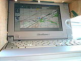
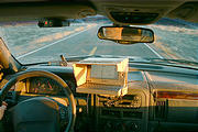
For navigation, I used a GPS connected to a tiny circa 1998 Toshiba Libretto 100CT notebook computer mounted on the dashboard of my 2000 Jeep Grand Cherokee. The Libretto was the smallest computer I could find, at only 8.3 x 5.2 x 1.4 inches. The screen is 7.1" diagonally, with a resolution of 800 x 480. It's barely fast enough to run Windows 2000.
With a GPS, software showed my current position on scanned USGS topographic maps.
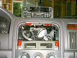
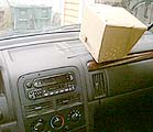
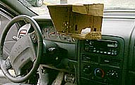
Yes, the computer mount/sunshade is made out of cardboard. (Let's just call it a "prototype".) It has two metal rods that slide into two hollow metal cylinders secured in the dash above the radio. The only visible modifications to the dash are two holes in the easily replaceable trim piece that borders the radio. For a future version, I'd construct it out of plastic, and add better cooling vents in the bottom.
GPS, Computer, Topographic Map Software Links

