GPS Maps for Mexico
Memory Map
[Update: January, 2011]
An Overland Journal article describes what appears to be the best option so far for digital GPS maps of Baja. I haven't tried Memory Map yet, but it definitely seems worth looking into! GoTrekkers.com sells a DVD of 1:50,000 topo maps for Baja that works with Memory Map software.

Below are some other options I've used or looked into in the past...
Garmin MapSource & nRoute
Garmin nRoute lets you use Garmin GPS format vector maps on your PC attached to a GPS. (Vector maps display well at many different zoom levels.) nRoute has been discontinued by Garmin, but it is still available online . Garmin now sells Garmin Mobile PC to fill this niche, but I have not tried this software myself. Garmin MapSource (still supported) is similar to nRoute, but does not support GPS-controlled moving-map.
Mexico GPS Atlas 2012 from BiciMapas.com
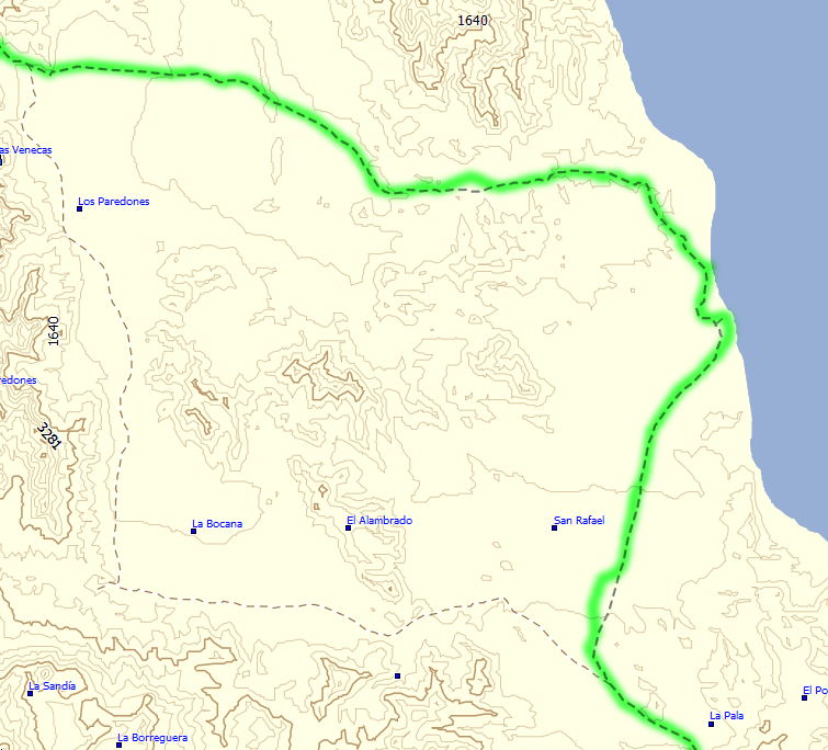
I use Mexico GPS Atlas 2012 from BiciMapas.com , a detailed Garmin-format vector map covering all of Mexico. It appears very similar in content to the INEGI 1:250,000 raster maps (see images further down this page). The BiciMapas Garmin maps share most of the same details, including many minor dirt roads. A few small details do seem to be lacking in these Garmin maps, though:
- Some named locations are not indicated with their type — is it a river, or a town, etc...?)
- Some bodies of water are missing (some bays, inlets)
- No coloring for terrain type (forest vs. marsh vs. playa, etc.)
OziExplorer
OziExplorer shows "raster " maps — static map images that can be scaled to some extent, but they will often look pixelated or unreadable at zoom sizes other than 100%.
I've successfully used digital Mexican government "INEGI" maps, and scanned copies of Landon Crumpton's book Baja Almanac with OziExplorer software on my notebook computer. The latter is not recommended.
INEGI maps from BiciMapas.com
I bought these OziExplorer-georeferenced map image (raster) files from from a company called BiciMapas , which sells digital scanned-in INEGI maps. I bought all four of their Mexico 1:250,000 raster map sets (all of Mexico). BiciMapas also sells more detailed (1:50,000) raster maps, as well as the Garmin-format vector maps mentioned above.
The OziExplorer software is available from http://www.oziexplorer.com/ .
BiciMapas Mexico GPS Atlas vs. INEGI 1:250,000 vs. Baja Almanac
(showing detail of San Rafael, Baja California, Mexico)
Compare my GPS track log (green highlight) overlaid on the following maps of the San Rafael area of Baja California. My track aligns almost perfectly with the first two maps (BiciMapas Mexico GPS Atlas, and INEGI 1:250,000 scale). The third map image is from Landon Crumpton's Baja Almanac , which shows many more wonderful details, but unfortunately they're not accurately positioned enough for GPS use. You can see how my GPS track overlay reveals gross misalignment problems.

BiciMapas Mexico GPS Atlas

INEGI 1:250,000

Baja Almanac 1:250,000
BiciMapas Mexico GPS Atlas vs. INEGI 1:250,000 vs. INEGI 1:50,000
(showing detail of Erongarícuaro, Michoacán, Mexico)
If you want street-level details (even individual buildings) for particular areas, the 1:50,000 INEGI raster maps are worth purchasing.

BiciMapas Mexico GPS Atlas

INEGI 1:250,000

INEGI 1:50,000
See Also
- Dash-Mounted Fujitsu P1120 notebook computer for GPS in a van
- Dash-Mounted Toshiba Libretto 100CT notebook computer for GPS in a car
- Travel in Mexico


