Kayaking in the North Gulf Islands
Geoff and I decided to head out and explore the northern part of the Gulf Islands in British Columbia over the week of June 21 through 25. It was the time of the greatest variance in tides of the year, as well as summer solstice. Perfect time to explore. As we hadn't done a trip in over a year, we decided that a trip to the "bathtub", as some have called the Gulf Islands, was in order. We had done much exploring of the southern portion, and had been to the Thetis Island Kayak Symposium, but hadn't done any paddling in that area. After a bit of research and reading, we decided to start at the top, near Galiano Island and head south towards Wallace Island, a favorite of a kayaking friend of ours.
Our first major challenge was pulling together all of our gear — as it had been quite some time since we had been out, as well as much of it had been hijacked for the Sportsmobile , we had some sorting to do. Pulling out old gear and food lists, finding proper equipment, buying a new stove and tarp, making runs to Madison Market and Trader Joes, we were ready by about noon on Tuesday. It was the last minute run to Kinko's to make some chart copies that nearly threw Laura over the edge. We were trying to make the 3:15 ferry in Tsawwassen, just north of Point Roberts. We left Seattle at 1 PM and waited to see what would happen. Shockingly enough (and with Geoff staying within the speed limit), we made it through the shortest border crossing ever, and arrived at the ferry terminal at 3:15. The ferry was just loading and the agent was able to sneak us on. Whew!
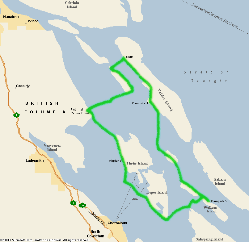
As we pulled off the ferry in Duke's Point, near Nanaimo, we started to notice the weather. We were planning on putting in at Cedar-by-the-Sea but when we arrived, we were greeted with pouring rain, gusts of wind at our faces, lightening and thunder. Oh, and it was 6 PM and very high tide. We decided to take a look at a launch point a bit further down the coast to see what the wind was like there — it was significantly less but at this point, it was closer to 7 PM, still extremely windy and we knew that the initial packing of the boats would take some time. After much agonizing on Laura's part (who wanted to just get on the water) we camped at a near by RV park and decided to start again in the morning.

Day 1
The weather reports stated that there would continue to be 15-25 knot winds in the morning but we arrived at Blue Heron Park at Yellow Point with sun and no wind! But the tide was almost completely receded out the beach — ugh! We carried our boats and gear down the beach, avoiding stepping on starfish and numerous tiny crabs, and struggled to fit all of our stuff into the two boats. Let's just say that we like to eat well and have lots of fresh veggies on our trips. Four heads of broccoli takes up a lot of space!
We finished packing and returned to the car to find... CRAP! The battery had died. Old car, weak battery, and leaving the car doors open with the interior lights on last night had killed it. It was parked as close as we could get to the water, so not an ideal place to leave it for four days. There were several people in the park but none with cars. A car finally drove in but with no jumper cables. They were nice enough to take Geoff to a nearby Lodge to see if we could borrow some cables from them. After a 15 minute wait while the caretaker finished his lunch, he found the cables and we jump started the car (thanks to the kindness of strangers!), we were finally on the water!


We had originally planned on camping at Pirate's Cove Provincial Park but now we were pumped to do some more paddling. We did the 2.5 mile open water crossing over to Pylades Island, passing the owner of the house on Tree Island who was burning his garbage. Paddling around the east side of Pylades, we stopped for lunch on a sandy beach before continuing on.


From here we could see the gorgeous wall across the channel on Valdes Island. This area is known for its amazing sandstone wall formations and we were wowed by what we found. Huge cliffs of sandstone formations, the sparkling light bouncing off the water onto the wall, late day yellow sun... something that words and pictures can only partially explain.


After being mesmerized for awhile, we continued south on Valdes towards Blackberry Point and our first campsite. I had heard this was a gorgeous site, facing west towards sunset, and fairly large. As we approached, we could hear the screams of girls across the water. Our hopes of being by ourselves for the night were dashed as we arrived to see a group of twenty or more people with tents, tarps, and screams of "Kayakers!" and "We have pizza! Vegetarian pizza!" I'm sure they thought they were going to lure us in to chat with them but we kept right on going. Fortunately, there was a site all the way at the other end of the beach in the trees that made things a little more peaceful. Up in the arbutus trees, we created a homey site, after picking up numerous pieces of driftwood to cover the poison oak that lined our path to the tent site. Look out for poison oak!


Day 2
The next morning we decided to stick around and poke around in the tidepools. This was part of the reason we had come over this particular time — to explore the lowest low tide of the year. After finding all sorts of fun things hiding in pools, under rocks and rock shelves, we headed back into the water. Just before we left, a hovercraft went zooming by — not every day that you see one of those!


Our goal was to paddle to Wallace Island , a BC Provincial Park that friends had raved about. We were fairly leisurely in our travel, exploring the shorelines, and finding some current heading our way, pulling into the island sometime after 6 PM. It was tremendously hot being on the water, with little wind and the blazing sun. We hid in the shady side of the islands as much as we could on our travel to Wallace. Arriving at the northern end, Chivers Point, we saw a set of kayaks at the site. Not knowing there were actually a total of 9 tent sites at that location, we continued onto Cabin Bay, a little ways down the eastern side of the island. Cabin Bay was empty and, in my opinion, a far better site. It only has two tent pads and has been marked as a single group camping site. Gorgeous location, quiet and all to ourselves.
We set up camp and then I found the one downside to this site — the nearest toilet was at the Chivers Point, about an 8 minute walk one way from our site. This became a familiar journey for us over the next two days that we camped there.
After arriving late, we cooked up a quick meal and explored our campsite. While we were washing our dishes, we noticed that the bioluminescence was out in full force. Pulling out our kayaks again, we took advantage of a cloudy moonless sky to explore the glowing waters by kayak. Our paddle strokes, the water streaming by the boat, all glowed as we moved along. Very very cool!
 - Kayaks")
")


Day 3
The next day we decided to take it easy and explore the island by foot. Try to give the rest of the body a workout! As the island is almost entirely park, we walked the 2 miles to the southern tip and back again, learning about the history of the island , seeing old structures and meeting a few folks along the way.
")


")


")
Day 4
The next morning we decided to try to catch the 5:45 PM ferry back in Nanaimo. We wanted to take a new route so we paddled through Houston Passage, in between Tent Island and Kuper Island, and then north back to Nanaimo. Fortunately, we timed it well and had the currents pushing us most of the way — strange, considering we're paddling south at some points and north at others — but that's the Gulf Islands for you!
The areas in between Tent Island and Kuper was amazing — definitely a place we'd like to get back and explore again. We arrived just before all the water had drained between the two islands and I finally found my first Moon Snail . I've been fascinated with these snails forever, as you see their egg casings littered all over the ocean floor. Literally, it looks like litter. These snails make a large flat rubbery spiral which seems as if it must be manmade. Finding the snail, I see why the casings are so big — the snail is HUGE! It's about a foot long and completely unable to pull itself back into its shell.
As we continued to paddle north, stopping for lunch, watching bald eagles, and moving along, far in the distance I saw what looked like a passenger airplane on the shore. What in the world might that be? Sure enough, as we got closer, it turned out to be a Boeing 737 passenger jet airplane, which we learned will soon be sunk into the water as an artificial reef ! Craziness. We're going to have to go back to watch the sinking!


Well, that's not quite the end of our story. As it turned out, we just missed the ferry — by only minutes — but had a wonderful night in Nanaimo, with hot showers, great pub food and a good night sleep. All of this made for a much more relaxing border crossing, especially when we were good little citizens and declared our grapefruit at the border. After having our names entered into the computer, the grapefruit confiscated and our car double checked for other possible threats to our national security, we were sent on our merry way.
Wallace Island Information
Posters from the Wallace Island site that have terrific information about paddling and exploring the area.